文字サイズ

文字サイズ
Tokushima Prefecture
Muroto-Anan Kaigan Quasi-National Park spreads through the coast between the south of Tokushima Prefecture and Muroto Cape, Kochi Prefecture. The coast line is varied with characteristics such as sandy beach, cliffs and rias coast line. A breathtaking vast expanse of the sea spreads beyond the capes, the edge of each coast. Now, let’s take a look at one city and three towns which are located in this park.

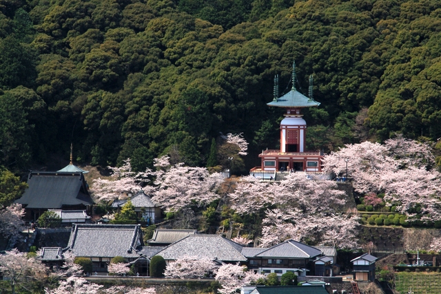
Anan City is blessed with nature: mild climate, the sea, mountains and rivers. The city boasts the world leading production of LED, while is also proud of its old history of tumuli and Awa navy, and a culture of welcoming Shikoku pilgrims.
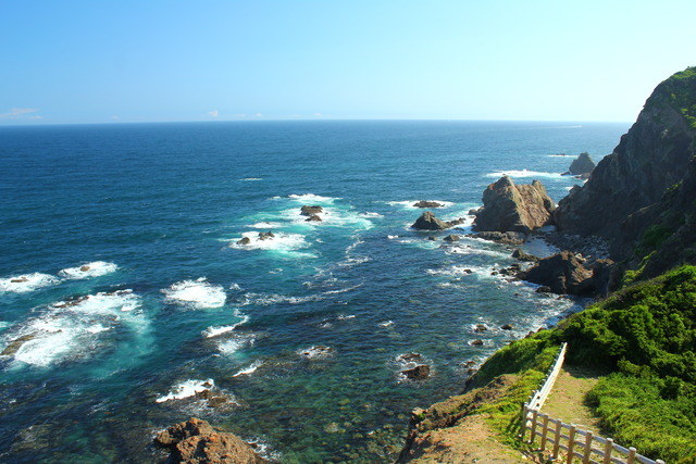
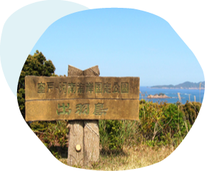
Kamoda Cape protruding towards Kii Channel is located in the easternmost in Shikoku.
Around the cape is said to be the place where the sun rises first in Shikoku, and the sun sometimes take a rare shape like Ω, called “Daruma Asahi” (sunrise looks like Japanese Daruma doll) at sunrise between late fall and winter. A white lighthouse standing on the top of the hill at the edge of the cape was first lit in 1924. Hino Cape in Wakayama Prefecture, Onaruto Bridge, Awaji Island can be seen from the observatory of the lighthouse.
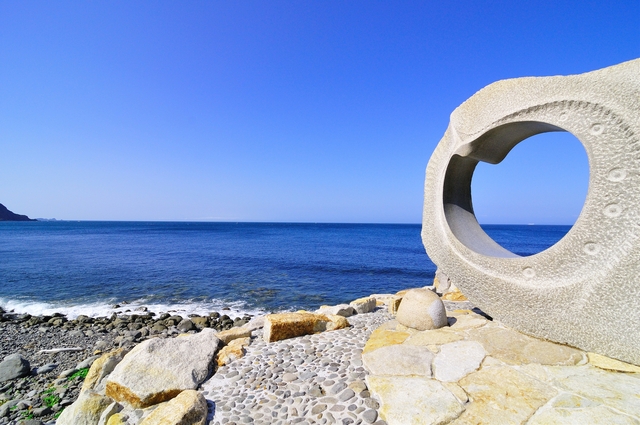
A monument made of stone is located on the side of the path entrance leading to the Kamoda Cape lighthouse. The monument was made by Mr. Fumiaki Otsu, an engraver living in Anan City. This large monument, of which the concept is waves and winds, is 2.6-meter high, 3.4-meter wide and 0.8-meter deep. Two people can sit inside of the heart shaped hole of the monument. You can see Ishima Island floating on the horizon from the hole and feel your emotions.

The hot springs are the hottest in the prefecture and have a good reputation to have less odor and are soft for the skin. You can admire Tsubakidomari on the opposite shore from “Umigame-no-Yu” (the open-air bath with the image of a sea turtle landing at the cape). You can also enjoy a panoramic view of the beautiful vast expanse of the sea up to Awaji Island from the high ground. Free rental bicycles are also available to take a look around.
Tsubakidomari-cho is situated in the south of the peninsula expanding towards Kii Channel between Tachibana Bay and Kamoda Cape. Houses are huddled together along both sides of the narrow street where only one car can go through. You can feel the warm human nature of a fishing village from these old style houses with vintage wood carving hand rails.
There are more than 700 types among the 3000 camellia trees in the garden including famous Japanese and foreign species. Advice on planting camellia trees, display and sales of seedlings are provided, and the Camellia Festival is held in March. Facilities include accommodation and a restaurant where local fresh seafood is offered. In addition to camellias, a magnificent view from the site, which is one of the 88 view points in Tokushima, is recommended!
Ishima Island, a 9.5-kilometer circumference island with a population of approximately 200, floats in Kii Channel, eastwards from Kamoda Cape. A white lighthouse is its landmark. Lilies (Lilium japonicum), characteristic species in the island, bloom gracefully in June. You can enjoy girella and black sea bream fishing as there is an uncountable number of rocky coasts in the island. The name of the island “Ijima” seems to have derived from the Japanese character “い” as the shape of the island, looking down from the sky, is similar to this character. How about coming to the island to have a relaxing time? Ferry boat service to Ijima Island is available three times a day from Kotaeshima. To Kotaeshima, five minutes’ walk from JR “Awa-Tachibana Station” (Mugi Line).
Mugi-cho is a town with an abundance of nature surrounded by woods and coasts, and a variety of sea creatures can be seen. “Teba Island” was selected as one of the “Top 100 of Japan’s historical and cultural assets of fishing villages that should be passed onto future generations” and “Top 100 of Japan’s paradises”. This old style island is also famous for its Art Exhibition.
Teba Island, a small island with a 4-kilometer circumference, is located in the sea 3.27 kilometers southward away from Mugi Port. Due to the Japanese Current, the average temperature reaches above 17 degrees Celsius. The mild climate enables pea flowers to blossom in mid-winter, and subtropical plants including hibiscuses and crinums to grow naturally. The view from Teba Island lighthouse is magnificent. You can enjoy a panoramic view of Kishu in the east, Muroto in the west, the Pacific Ocean in the south and Shikoku Mountains in the north. The name of the island used to be “Teha” or “Deha” in the olden days.

The height of the eaves of private houses is low in order to avoid damage by winds. The eaves and smoked roof tiles aligning the street are impressive. There are many buildings built in early Meiji Period (late 19th century), however it is rare that a quite good sized fishing village still remains. Foldable wooden doors (shutters for rain) called “Mise” are fitted in upper frames, “Uemise”, and in lower frames “Shitamise” in those houses. Shitamise is usually used as a bench or table to mend fishing gear. (Some houses have “Shitamise” only.)
The path is actually a proper hiking course covering the whole island. Walking through the old townscape is like a time travel to olden days. Take a good walk along the vast coastline. The Sightseeing Path Central Course is a one-kilo meter course from the port to the lighthouse on top of the mountain with a height of 76.6 meters. The light of the “Teba lighthouse” reaches up to 38 kilometers.


Oshima and Tsushima Islands are busy with many people, who like fishing from the rocks by the shore, as fishing can be enjoyed throughout the year. Many types of fish such as parrot fish, girella, dusky spinefoot, young yellow tail, skipjack tuna, grunt and red snapper, inhabit off-shore of Mugi where the Japanese Current flows.
There are almost no cars in the islands, therefore, you can find only “paths” for pedestrians. Wheelbarrows are essential for carrying goods and used be very useful for women to carry water from common wells as it used to be hard work without wheelbarrows.
You can enjoy local cuisine such as “Island’s Somen noodles”, “Cooked moray with grated white radish”, “pressed sushi” and other popular local menus such as “black noodle with squid ink”, “fried squid burger” and “Minami Awa bowl of rice”. Please come to try them!
The town where culture and history remain strongly. There is a museum regarding sea turtles, the symbol of the town. Lots of choices of goods and souvenirs related to sea turtles make you unable to choose what to buy.
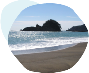
The coast is well known as the sea turtles’ spawning ground. Green turtles come to the beach to lay eggs between mid-May and mid-August every year. The beach was designated as a national natural monument in 1967, and is a scenic spot which was selected as one of the “Top 100 of Japan’s most beautiful beaches” in 1996.

You can learn about turtles while watching turtles actually swimming. There are lots to see such as display of world sea turtles, water tank of child turtles, chronological table of turtle’s evolutionary history, outdoor pool for breeding turtles and sea turtle-shaped public phone! You can enjoy a panoramic view of Ohama Beach from the observatory in the museum. If you are lucky, you might be able to see moving scenes of loggerhead turtles laying eggs at the beach between Jun and August every year.
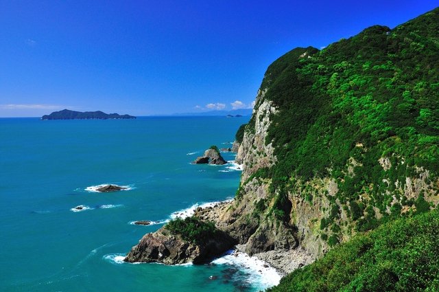
Senba Cliffs can be viewed from the path starting from Hiwasa Castle and Minami Awa Sun Line. The fault and erosion made the cliffs vertical and approximately two kilometers in length, and they are one of the best cliffs in Japan. At the highest point around Mt. Senbagadake, the cliffs, with a height of approximately 250 meter, drop vertically towards the sea. It is a splendid view, if you take a look at them closely. A view from a sea kayak is recommended, too.
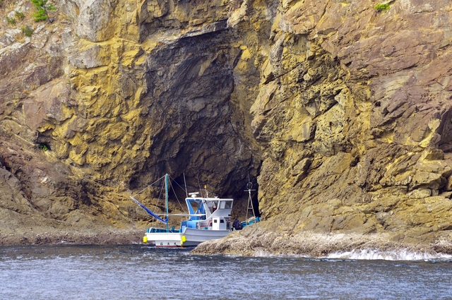
A fishing boat steered by a fisherman departs from Port of Hiwasa and visits “Tori Iwa” (rock), the Senba Cliffs and large Ebisu Cave. The total cruise length is 13 kilometers and takes approximately 40 minutes. Only customers joining the cruise can order special menus for fishermen.
It is said that the Governor of Hisawa Hizen built the castle as a fortification on a place with a height of 70 meters to prevent an invasion of Chosokabe Motochika from Tosa. The castle became disused when Hachisuka Iemasa entered Awa. The castle tower was restored in September 1984. It is open to the public to enjoy the view.

The 23rd temple of Shikoku pilgrimage. There are the stairs which it is said that you can avoid disasters if you go up leaving one-yen coins. You can also visit lots of must-see spots including the healing Buddha facing back in the main temple and “Hai Taishi” where miraculous radium spring water is gushing out.
It is an 18-kilometer road connecting Hiwasa area and Mugi-cho with a superb view of the Pacific Ocean. A part of Senba Cliffs can be seen from an observation point. Lots of bikers and car drivers enjoying a touring visit there on weekends and holidays. The sea, mountains and river are very close so that you can fully enjoy nature. You might encounter monkeys, too.
Kaiyo-cho is the place where rivers including Kaifu River originate from the area with lush greenery mountains and flow into the Pacific Ocean. It boasts a beautiful blue inlet and cape. Takegashima Island blessed with colonial coral and dancing tropical fish has lots to offer from sightseeing boats to kayak experiences!
Under the shining sea among the dotted islands is the most beautiful scenic spot in Muroto-Anan Kaigan Quasi-National Park, boasting its magnificent southern country-like coast. It is famous for its connection by the bridge and the hub of tuna fishing.
21 types of coral such as acropora tumida, avona decussate Dana and Astraeidae, and colorful tropical fish including blue damselfish, Clerk’s anemonefish and belted beard grunt add to the color off the coast.
The tourist boat offers a round trip of “Takegashima Island” taking approximately 45 minutes. You can enjoy a panoramic view and scent of the Japanese Current from the deck, and see beautiful coral and tropical fish closely from the large windows at the bottom of the boat. You will feel as if you were walking in the sea.


These activities offer various ways to enjoy Takegashima Marine Park: sea kayak provides you opportunities to see wonderful views with extraordinarily shaped rocks formed by the long term effect of rough waves and beautiful little islands floating on the sea, and scuba diving and snorkelling enables you to observe coral and tropical fish. Kaifu Point, the mouth of Kaifu River is very popular for surfers and they come from all over the country.
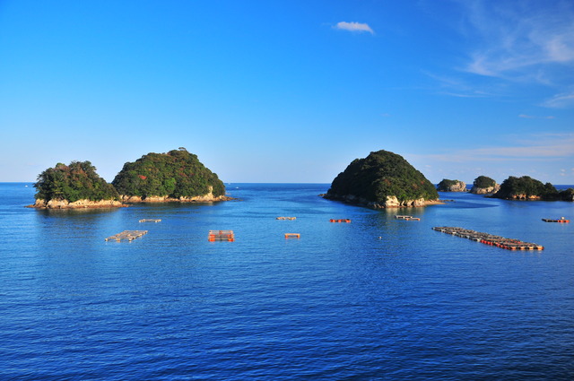
Mitoko Bay is considered as the gem of Nankai district. It could be called “suisho” (different way of pronouncing its name in Kanji) which also means a “crystal” like the sea which is so beautiful and its water transparency is high. Rias coastline creates a variety of picturesque sights with extraordinarily shaped rocks such as Eboshi-iwa, Zato-iwa and Kaburi-iwa.
The camping ground is located on the high ground looking down on Asakawa Bay. One of Shikoku’s foremost high standard auto camping grounds. Accommodation (cottages, partitioned camping sites, free camping sites, etc.) and facilities for one-day visits (BBQ sites, gymnasium, Jacuzzis, etc.) and rental goods are available. The whole area is seven hectares and each individual site is 100–120m². Both small and large groups can enjoy comfortable camping.
Copyright © Tokushima Prefecture, All rights reserved.

 SNS
SNS